|
|
|||||||||||||||||
| Point ID: 5373 | Downloads | Plots | Site Data | Code: 05JF012 |
|
|
|||||||||||||||||
| Download | |
|---|---|
| Site Descriptor Information | Site Time Series Data |
| Link to all available data | |
| View: | Time Series | All |
| Units: | m3/s |
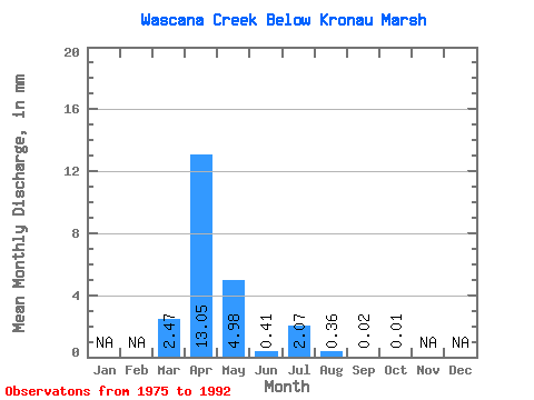
| Statistic | Jan | Feb | Mar | Apr | May | Jun | Jul | Aug | Sep | Oct | Nov | Dec | Annual |
|---|---|---|---|---|---|---|---|---|---|---|---|---|---|
| Mean | 0.80 | 4.23 | 1.61 | 0.13 | 0.67 | 0.12 | 0.01 | 0.00 | |||||
| Standard Deviation | 1.24 | 6.39 | 3.73 | 0.23 | 1.59 | 0.22 | 0.01 | 0.00 | |||||
| Min | 0.00 | 0.01 | 0.00 | 0.00 | 0.00 | 0.00 | 0.00 | 0.00 | |||||
| Max | 3.77 | 22.35 | 14.92 | 0.88 | 6.40 | 0.74 | 0.05 | 0.01 | |||||
| Coefficient of Variation | 1.55 | 1.51 | 2.31 | 1.73 | 2.37 | 1.89 | 2.43 | 1.72 |
 Return to R-Arctic Net Home Page