|
|
|||||||||||||||||
| Point ID: 5371 | Downloads | Plots | Site Data | Code: 05JF009 |
|
|
|||||||||||||||||
| Download | |
|---|---|
| Site Descriptor Information | Site Time Series Data |
| Link to all available data | |
| View: | Time Series | All |
| Units: | mm |
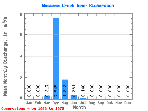
| Statistic | Jan | Feb | Mar | Apr | May | Jun | Jul | Aug | Sep | Oct | Nov | Dec | Annual |
|---|---|---|---|---|---|---|---|---|---|---|---|---|---|
| Mean | 0.00 | 0.00 | 0.32 | 7.54 | 1.81 | 0.36 | 0.14 | 0.00 | 0.00 | 0.00 | 0.00 | 0.00 | 0.08 |
| Standard Deviation | 0.00 | 0.00 | 0.60 | 8.71 | 4.72 | 0.79 | 0.36 | 0.00 | 0.00 | 0.00 | 0.00 | 0.00 | 0.10 |
| Min | 0.00 | 0.00 | 0.00 | 0.00 | 0.00 | 0.00 | 0.00 | 0.00 | 0.00 | 0.00 | 0.00 | 0.00 | 0.01 |
| Max | 0.00 | 0.00 | 1.75 | 27.30 | 16.60 | 2.01 | 1.18 | 0.00 | 0.00 | 0.00 | 0.00 | 0.00 | 0.15 |
| Coefficient of Variation | 1.88 | 1.16 | 2.60 | 2.19 | 2.56 | 1.16 |
 Return to R-Arctic Net Home Page