|
|
|||||||||||||||||
| Point ID: 5371 | Downloads | Plots | Site Data | Code: 05JF009 |
|
|
|||||||||||||||||
| Download | |
|---|---|
| Site Descriptor Information | Site Time Series Data |
| Link to all available data | |
| View: | Time Series | All |
| Units: | m3/s |
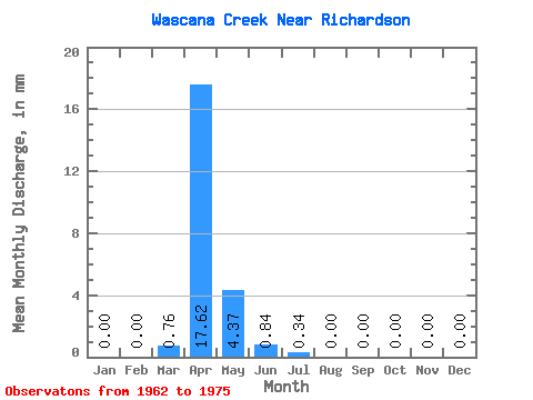
| Statistic | Jan | Feb | Mar | Apr | May | Jun | Jul | Aug | Sep | Oct | Nov | Dec | Annual |
|---|---|---|---|---|---|---|---|---|---|---|---|---|---|
| Mean | 0.00 | 0.00 | 0.27 | 6.25 | 1.55 | 0.30 | 0.12 | 0.00 | 0.00 | 0.00 | 0.00 | 0.00 | 0.82 |
| Standard Deviation | 0.00 | 0.00 | 0.51 | 7.22 | 4.04 | 0.65 | 0.31 | 0.00 | 0.00 | 0.00 | 0.00 | 0.00 | 0.95 |
| Min | 0.00 | 0.00 | 0.00 | 0.00 | 0.00 | 0.00 | 0.00 | 0.00 | 0.00 | 0.00 | 0.00 | 0.00 | 0.15 |
| Max | 0.00 | 0.00 | 1.50 | 22.61 | 14.20 | 1.67 | 1.01 | 0.00 | 0.00 | 0.00 | 0.00 | 0.00 | 1.50 |
| Coefficient of Variation | 1.88 | 1.16 | 2.60 | 2.19 | 2.56 | 1.16 |
 Return to R-Arctic Net Home Page