|
|
|||||||||||||||||
| Point ID: 5368 | Downloads | Plots | Site Data | Code: 05JF006 |
|
|
|||||||||||||||||
| Download | |
|---|---|
| Site Descriptor Information | Site Time Series Data |
| Link to all available data | |
| View: | Time Series | All |
| Units: | mm |
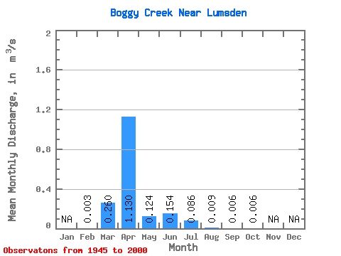
| Statistic | Jan | Feb | Mar | Apr | May | Jun | Jul | Aug | Sep | Oct | Nov | Dec | Annual |
|---|---|---|---|---|---|---|---|---|---|---|---|---|---|
| Mean | 0.00 | 0.26 | 1.13 | 0.12 | 0.15 | 0.09 | 0.01 | 0.01 | 0.01 | ||||
| Standard Deviation | 0.00 | 0.45 | 1.56 | 0.43 | 0.57 | 0.21 | 0.02 | 0.01 | 0.01 | ||||
| Min | 0.00 | 0.00 | 0.00 | 0.00 | 0.00 | 0.00 | 0.00 | 0.00 | 0.00 | ||||
| Max | 0.01 | 1.77 | 5.64 | 3.13 | 3.86 | 0.92 | 0.09 | 0.07 | 0.02 | ||||
| Coefficient of Variation | 0.82 | 1.72 | 1.38 | 3.50 | 3.73 | 2.46 | 2.03 | 1.85 | 0.78 |
 Return to R-Arctic Net Home Page