|
|
|||||||||||||||||
| Point ID: 5368 | Downloads | Plots | Site Data | Code: 05JF006 |
|
|
|||||||||||||||||
| Download | |
|---|---|
| Site Descriptor Information | Site Time Series Data |
| Link to all available data | |
| View: | Time Series | All |
| Units: | m3/s |
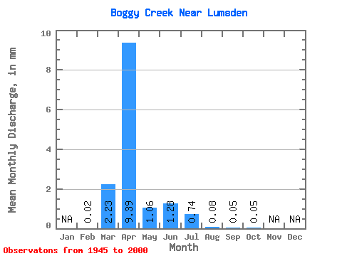
| Statistic | Jan | Feb | Mar | Apr | May | Jun | Jul | Aug | Sep | Oct | Nov | Dec | Annual |
|---|---|---|---|---|---|---|---|---|---|---|---|---|---|
| Mean | 0.02 | 1.74 | 7.30 | 0.83 | 0.99 | 0.58 | 0.06 | 0.04 | 0.04 | ||||
| Standard Deviation | 0.01 | 2.99 | 10.07 | 2.90 | 3.71 | 1.42 | 0.12 | 0.07 | 0.03 | ||||
| Min | 0.00 | 0.00 | 0.03 | 0.01 | 0.00 | 0.00 | 0.00 | 0.00 | 0.00 | ||||
| Max | 0.03 | 11.82 | 36.46 | 20.90 | 24.95 | 6.12 | 0.59 | 0.48 | 0.15 | ||||
| Coefficient of Variation | 0.82 | 1.72 | 1.38 | 3.50 | 3.73 | 2.46 | 2.03 | 1.85 | 0.78 |
 Return to R-Arctic Net Home Page