|
|
|||||||||||||||||
| Point ID: 5367 | Downloads | Plots | Site Data | Code: 05JF005 |
|
|
|||||||||||||||||
| Download | |
|---|---|
| Site Descriptor Information | Site Time Series Data |
| Link to all available data | |
| View: | Time Series | All |
| Units: | mm |
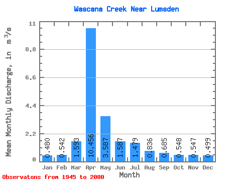
| Statistic | Jan | Feb | Mar | Apr | May | Jun | Jul | Aug | Sep | Oct | Nov | Dec | Annual |
|---|---|---|---|---|---|---|---|---|---|---|---|---|---|
| Mean | 0.48 | 0.54 | 1.59 | 10.46 | 3.59 | 1.59 | 1.48 | 0.84 | 0.69 | 0.55 | 0.55 | 0.50 | 2.29 |
| Standard Deviation | 0.11 | 0.14 | 2.04 | 12.22 | 5.00 | 1.94 | 1.97 | 0.62 | 0.38 | 0.32 | 0.19 | 0.13 | 1.63 |
| Min | 0.24 | 0.29 | 0.02 | 0.33 | 0.24 | 0.18 | 0.15 | 0.14 | 0.07 | 0.16 | 0.17 | 0.13 | 0.61 |
| Max | 0.66 | 0.82 | 10.80 | 46.60 | 23.70 | 12.80 | 12.10 | 3.24 | 2.09 | 1.69 | 0.97 | 0.69 | 5.88 |
| Coefficient of Variation | 0.23 | 0.26 | 1.28 | 1.17 | 1.39 | 1.22 | 1.33 | 0.74 | 0.55 | 0.58 | 0.35 | 0.27 | 0.71 |
 Return to R-Arctic Net Home Page