|
|
|||||||||||||||||
| Point ID: 5367 | Downloads | Plots | Site Data | Code: 05JF005 |
|
|
|||||||||||||||||
| Download | |
|---|---|
| Site Descriptor Information | Site Time Series Data |
| Link to all available data | |
| View: | Time Series | All |
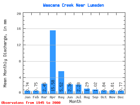
| Units: | m3/s |
| Statistic | Jan | Feb | Mar | Apr | May | Jun | Jul | Aug | Sep | Oct | Nov | Dec | Annual |
|---|---|---|---|---|---|---|---|---|---|---|---|---|---|
| Mean | 0.33 | 0.34 | 1.11 | 7.04 | 2.50 | 1.07 | 1.03 | 0.58 | 0.46 | 0.38 | 0.37 | 0.35 | 18.76 |
| Standard Deviation | 0.08 | 0.09 | 1.42 | 8.23 | 3.48 | 1.31 | 1.37 | 0.43 | 0.25 | 0.22 | 0.13 | 0.09 | 13.33 |
| Min | 0.17 | 0.19 | 0.01 | 0.22 | 0.17 | 0.12 | 0.10 | 0.10 | 0.05 | 0.11 | 0.11 | 0.09 | 5.03 |
| Max | 0.46 | 0.52 | 7.51 | 31.37 | 16.48 | 8.62 | 8.42 | 2.25 | 1.41 | 1.18 | 0.65 | 0.48 | 48.24 |
| Coefficient of Variation | 0.23 | 0.26 | 1.28 | 1.17 | 1.39 | 1.22 | 1.33 | 0.74 | 0.55 | 0.58 | 0.35 | 0.27 | 0.71 |
 Return to R-Arctic Net Home Page