|
|
|||||||||||||||||
| Point ID: 535 | Downloads | Plots | Site Data | Code: 05FA018 |
|
|
|||||||||||||||||
| Download | |
|---|---|
| Site Descriptor Information | Site Time Series Data |
| Link to all available data | |
| View: | Time Series | All |
| Units: | mm |
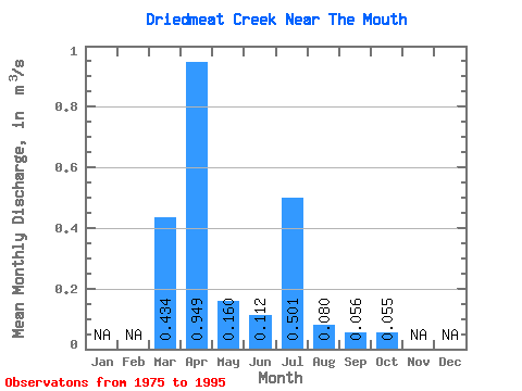
| Statistic | Jan | Feb | Mar | Apr | May | Jun | Jul | Aug | Sep | Oct | Nov | Dec | Annual |
|---|---|---|---|---|---|---|---|---|---|---|---|---|---|
| Mean | 0.43 | 0.95 | 0.16 | 0.11 | 0.50 | 0.08 | 0.06 | 0.06 | |||||
| Standard Deviation | 0.58 | 0.82 | 0.19 | 0.20 | 1.35 | 0.16 | 0.07 | 0.05 | |||||
| Min | 0.00 | 0.07 | 0.04 | 0.01 | 0.01 | 0.00 | 0.00 | 0.01 | |||||
| Max | 2.18 | 3.08 | 0.66 | 0.85 | 4.50 | 0.74 | 0.34 | 0.22 | |||||
| Coefficient of Variation | 1.34 | 0.86 | 1.17 | 1.76 | 2.70 | 1.98 | 1.31 | 0.97 |
 Return to R-Arctic Net Home Page