|
|
|||||||||||||||||
| Point ID: 535 | Downloads | Plots | Site Data | Code: 05FA018 |
|
|
|||||||||||||||||
| Download | |
|---|---|
| Site Descriptor Information | Site Time Series Data |
| Link to all available data | |
| View: | Time Series | All |
| Units: | m3/s |
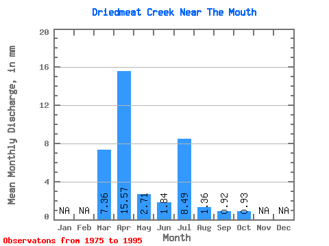
| Statistic | Jan | Feb | Mar | Apr | May | Jun | Jul | Aug | Sep | Oct | Nov | Dec | Annual |
|---|---|---|---|---|---|---|---|---|---|---|---|---|---|
| Mean | 1.01 | 2.14 | 0.37 | 0.25 | 1.17 | 0.19 | 0.13 | 0.13 | |||||
| Standard Deviation | 1.35 | 1.85 | 0.44 | 0.45 | 3.15 | 0.37 | 0.17 | 0.12 | |||||
| Min | 0.00 | 0.17 | 0.09 | 0.03 | 0.03 | 0.01 | 0.01 | 0.01 | |||||
| Max | 5.08 | 6.94 | 1.55 | 1.91 | 10.48 | 1.72 | 0.76 | 0.52 | |||||
| Coefficient of Variation | 1.34 | 0.86 | 1.17 | 1.76 | 2.70 | 1.98 | 1.31 | 0.97 |
 Return to R-Arctic Net Home Page