|
|
|||||||||||||||||
| Point ID: 5343 | Downloads | Plots | Site Data | Code: 05JB001 |
|
|
|||||||||||||||||
| Download | |
|---|---|
| Site Descriptor Information | Site Time Series Data |
| Link to all available data | |
| View: | Time Series | All |
| Units: | mm |
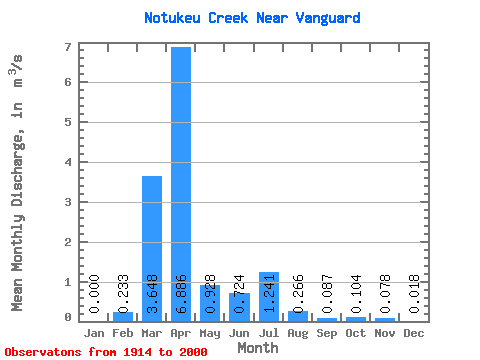
| Statistic | Jan | Feb | Mar | Apr | May | Jun | Jul | Aug | Sep | Oct | Nov | Dec | Annual |
|---|---|---|---|---|---|---|---|---|---|---|---|---|---|
| Mean | 0.00 | 0.23 | 3.65 | 6.89 | 0.93 | 0.72 | 1.24 | 0.27 | 0.09 | 0.10 | 0.08 | 0.02 | 1.20 |
| Standard Deviation | 0.00 | 0.57 | 5.79 | 10.26 | 1.25 | 1.40 | 4.40 | 0.86 | 0.13 | 0.13 | 0.11 | 0.02 | 0.99 |
| Min | 0.00 | 0.00 | 0.00 | 0.04 | 0.00 | 0.00 | 0.00 | 0.00 | 0.00 | 0.00 | 0.00 | 0.00 | 0.21 |
| Max | 0.00 | 2.18 | 28.60 | 66.70 | 5.72 | 10.10 | 27.40 | 6.24 | 0.70 | 0.58 | 0.34 | 0.04 | 3.01 |
| Coefficient of Variation | 2.46 | 1.59 | 1.49 | 1.35 | 1.94 | 3.54 | 3.22 | 1.52 | 1.22 | 1.36 | 0.93 | 0.82 |
 Return to R-Arctic Net Home Page