|
|
|||||||||||||||||
| Point ID: 5343 | Downloads | Plots | Site Data | Code: 05JB001 |
|
|
|||||||||||||||||
| Download | |
|---|---|
| Site Descriptor Information | Site Time Series Data |
| Link to all available data | |
| View: | Time Series | All |
| Units: | m3/s |
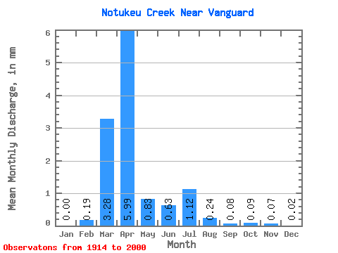
| Statistic | Jan | Feb | Mar | Apr | May | Jun | Jul | Aug | Sep | Oct | Nov | Dec | Annual |
|---|---|---|---|---|---|---|---|---|---|---|---|---|---|
| Mean | 0.00 | 0.16 | 2.76 | 5.04 | 0.70 | 0.53 | 0.94 | 0.20 | 0.06 | 0.08 | 0.06 | 0.01 | 10.72 |
| Standard Deviation | 0.00 | 0.40 | 4.38 | 7.51 | 0.95 | 1.03 | 3.33 | 0.65 | 0.10 | 0.10 | 0.08 | 0.01 | 8.82 |
| Min | 0.00 | 0.00 | 0.00 | 0.03 | 0.00 | 0.00 | 0.00 | 0.00 | 0.00 | 0.00 | 0.00 | 0.00 | 1.85 |
| Max | 0.00 | 1.50 | 21.64 | 48.84 | 4.33 | 7.39 | 20.73 | 4.72 | 0.52 | 0.44 | 0.25 | 0.03 | 26.80 |
| Coefficient of Variation | 2.46 | 1.59 | 1.49 | 1.35 | 1.94 | 3.54 | 3.22 | 1.52 | 1.22 | 1.36 | 0.93 | 0.82 |
 Return to R-Arctic Net Home Page