|
|
|||||||||||||||||
| Point ID: 5340 | Downloads | Plots | Site Data | Code: 05JA002 |
|
|
|||||||||||||||||
| Download | |
|---|---|
| Site Descriptor Information | Site Time Series Data |
| Link to all available data | |
| View: | Time Series | All |
| Units: | mm |
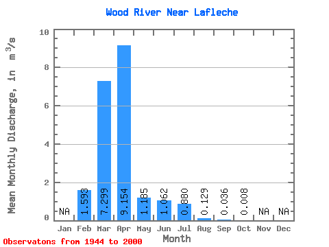
| Statistic | Jan | Feb | Mar | Apr | May | Jun | Jul | Aug | Sep | Oct | Nov | Dec | Annual |
|---|---|---|---|---|---|---|---|---|---|---|---|---|---|
| Mean | 1.59 | 7.30 | 9.15 | 1.19 | 1.06 | 0.88 | 0.13 | 0.04 | 0.01 | ||||
| Standard Deviation | 3.64 | 11.11 | 15.52 | 1.88 | 2.90 | 2.96 | 0.21 | 0.09 | 0.02 | ||||
| Min | 0.00 | 0.00 | 0.02 | 0.00 | 0.00 | 0.00 | 0.00 | 0.00 | 0.00 | ||||
| Max | 11.20 | 56.00 | 98.30 | 8.37 | 17.10 | 19.20 | 0.94 | 0.42 | 0.13 | ||||
| Coefficient of Variation | 2.29 | 1.52 | 1.69 | 1.58 | 2.73 | 3.36 | 1.64 | 2.61 | 3.02 |
 Return to R-Arctic Net Home Page