|
|
|||||||||||||||||
| Point ID: 5340 | Downloads | Plots | Site Data | Code: 05JA002 |
|
|
|||||||||||||||||
| Download | |
|---|---|
| Site Descriptor Information | Site Time Series Data |
| Link to all available data | |
| View: | Time Series | All |
| Units: | m3/s |
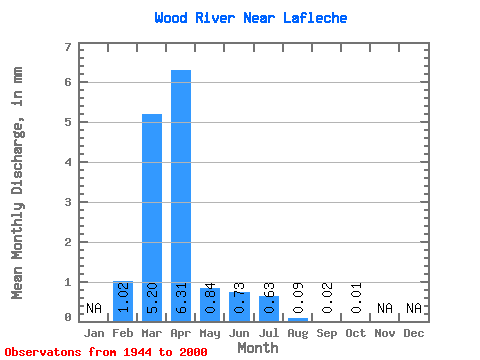
| Statistic | Jan | Feb | Mar | Apr | May | Jun | Jul | Aug | Sep | Oct | Nov | Dec | Annual |
|---|---|---|---|---|---|---|---|---|---|---|---|---|---|
| Mean | 0.82 | 4.13 | 5.02 | 0.67 | 0.58 | 0.50 | 0.07 | 0.02 | 0.00 | ||||
| Standard Deviation | 1.88 | 6.29 | 8.50 | 1.06 | 1.59 | 1.68 | 0.12 | 0.05 | 0.01 | ||||
| Min | 0.00 | 0.00 | 0.01 | 0.00 | 0.00 | 0.00 | 0.00 | 0.00 | 0.00 | ||||
| Max | 5.78 | 31.71 | 53.87 | 4.74 | 9.37 | 10.87 | 0.53 | 0.23 | 0.07 | ||||
| Coefficient of Variation | 2.29 | 1.52 | 1.69 | 1.58 | 2.73 | 3.36 | 1.64 | 2.61 | 3.02 |
 Return to R-Arctic Net Home Page