|
|
|||||||||||||||||
| Point ID: 5306 | Downloads | Plots | Site Data | Code: 05HE001 |
|
|
|||||||||||||||||
| Download | |
|---|---|
| Site Descriptor Information | Site Time Series Data |
| Link to all available data | |
| View: | Time Series | All |
| Units: | mm |
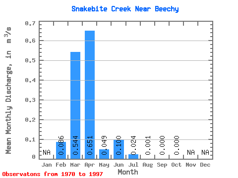
| Statistic | Jan | Feb | Mar | Apr | May | Jun | Jul | Aug | Sep | Oct | Nov | Dec | Annual |
|---|---|---|---|---|---|---|---|---|---|---|---|---|---|
| Mean | 0.09 | 0.54 | 0.65 | 0.05 | 0.10 | 0.02 | 0.00 | 0.00 | 0.00 | ||||
| Standard Deviation | 0.14 | 0.96 | 1.10 | 0.10 | 0.36 | 0.08 | 0.00 | 0.00 | 0.00 | ||||
| Min | 0.00 | 0.00 | 0.00 | 0.00 | 0.00 | 0.00 | 0.00 | 0.00 | 0.00 | ||||
| Max | 0.34 | 3.98 | 3.59 | 0.40 | 1.93 | 0.41 | 0.01 | 0.01 | 0.00 | ||||
| Coefficient of Variation | 1.63 | 1.76 | 1.68 | 1.95 | 3.63 | 3.46 | 3.18 | 5.29 | 3.88 |
 Return to R-Arctic Net Home Page