|
|
|||||||||||||||||
| Point ID: 5306 | Downloads | Plots | Site Data | Code: 05HE001 |
|
|
|||||||||||||||||
| Download | |
|---|---|
| Site Descriptor Information | Site Time Series Data |
| Link to all available data | |
| View: | Time Series | All |
| Units: | m3/s |
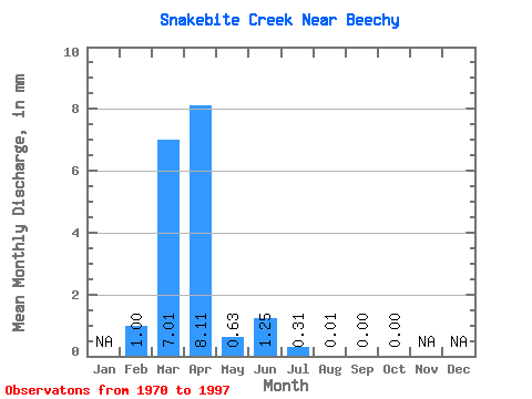
| Statistic | Jan | Feb | Mar | Apr | May | Jun | Jul | Aug | Sep | Oct | Nov | Dec | Annual |
|---|---|---|---|---|---|---|---|---|---|---|---|---|---|
| Mean | 0.24 | 1.69 | 1.96 | 0.15 | 0.30 | 0.07 | 0.00 | 0.00 | 0.00 | ||||
| Standard Deviation | 0.40 | 2.97 | 3.30 | 0.29 | 1.10 | 0.25 | 0.01 | 0.00 | 0.00 | ||||
| Min | 0.00 | 0.00 | 0.00 | 0.00 | 0.00 | 0.00 | 0.00 | 0.00 | 0.00 | ||||
| Max | 0.97 | 12.38 | 10.81 | 1.23 | 5.81 | 1.28 | 0.04 | 0.01 | 0.01 | ||||
| Coefficient of Variation | 1.63 | 1.76 | 1.68 | 1.95 | 3.63 | 3.46 | 3.18 | 5.29 | 3.88 |
 Return to R-Arctic Net Home Page