|
|
|||||||||||||||||
| Point ID: 5303 | Downloads | Plots | Site Data | Code: 05HD038 |
|
|
|||||||||||||||||
| Download | |
|---|---|
| Site Descriptor Information | Site Time Series Data |
| Link to all available data | |
| View: | Time Series | All |
| Units: | mm |
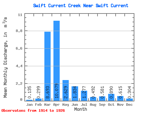
| Statistic | Jan | Feb | Mar | Apr | May | Jun | Jul | Aug | Sep | Oct | Nov | Dec | Annual |
|---|---|---|---|---|---|---|---|---|---|---|---|---|---|
| Mean | 0.14 | 0.30 | 8.69 | 10.08 | 2.63 | 1.83 | 1.28 | 0.49 | 0.58 | 0.89 | 0.61 | 0.30 | 2.32 |
| Standard Deviation | 0.07 | 0.36 | 9.77 | 9.56 | 2.39 | 1.71 | 1.98 | 0.48 | 0.50 | 0.41 | 0.26 | 0.11 | 1.30 |
| Min | 0.00 | 0.00 | 0.07 | 2.25 | 1.15 | 0.32 | 0.07 | 0.01 | 0.17 | 0.41 | 0.26 | 0.11 | 0.79 |
| Max | 0.25 | 1.39 | 28.80 | 38.20 | 10.20 | 6.70 | 7.51 | 1.75 | 1.86 | 1.55 | 1.30 | 0.51 | 4.87 |
| Coefficient of Variation | 0.51 | 1.22 | 1.12 | 0.95 | 0.91 | 0.93 | 1.55 | 0.98 | 0.86 | 0.46 | 0.42 | 0.36 | 0.56 |
 Return to R-Arctic Net Home Page