|
|
|||||||||||||||||
| Point ID: 5303 | Downloads | Plots | Site Data | Code: 05HD038 |
|
|
|||||||||||||||||
| Download | |
|---|---|
| Site Descriptor Information | Site Time Series Data |
| Link to all available data | |
| View: | Time Series | All |
| Units: | m3/s |
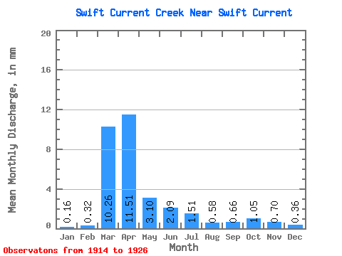
| Statistic | Jan | Feb | Mar | Apr | May | Jun | Jul | Aug | Sep | Oct | Nov | Dec | Annual |
|---|---|---|---|---|---|---|---|---|---|---|---|---|---|
| Mean | 0.11 | 0.23 | 7.37 | 8.27 | 2.23 | 1.50 | 1.08 | 0.42 | 0.48 | 0.75 | 0.51 | 0.26 | 23.16 |
| Standard Deviation | 0.06 | 0.28 | 8.28 | 7.84 | 2.03 | 1.40 | 1.68 | 0.41 | 0.41 | 0.34 | 0.21 | 0.09 | 12.95 |
| Min | 0.00 | 0.00 | 0.06 | 1.85 | 0.97 | 0.26 | 0.06 | 0.01 | 0.14 | 0.35 | 0.21 | 0.09 | 7.86 |
| Max | 0.21 | 1.07 | 24.41 | 31.33 | 8.64 | 5.50 | 6.36 | 1.48 | 1.53 | 1.31 | 1.07 | 0.43 | 48.59 |
| Coefficient of Variation | 0.51 | 1.22 | 1.12 | 0.95 | 0.91 | 0.93 | 1.55 | 0.98 | 0.86 | 0.46 | 0.42 | 0.36 | 0.56 |
 Return to R-Arctic Net Home Page