|
|
|||||||||||||||||
| Point ID: 5299 | Downloads | Plots | Site Data | Code: 05HD031 |
|
|
|||||||||||||||||
| Download | |
|---|---|
| Site Descriptor Information | Site Time Series Data |
| Link to all available data | |
| View: | Time Series | All |
| Units: | mm |
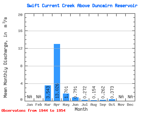
| Statistic | Jan | Feb | Mar | Apr | May | Jun | Jul | Aug | Sep | Oct | Nov | Dec | Annual |
|---|---|---|---|---|---|---|---|---|---|---|---|---|---|
| Mean | 3.54 | 13.03 | 1.70 | 0.79 | 0.27 | 0.15 | 0.26 | 0.37 | |||||
| Standard Deviation | 3.69 | 16.48 | 1.49 | 0.87 | 0.17 | 0.15 | 0.39 | 0.36 | |||||
| Min | 0.35 | 1.32 | 0.32 | 0.13 | 0.06 | 0.01 | 0.00 | 0.04 | |||||
| Max | 9.93 | 57.50 | 5.77 | 3.22 | 0.54 | 0.41 | 1.10 | 1.35 | |||||
| Coefficient of Variation | 1.04 | 1.27 | 0.88 | 1.09 | 0.60 | 0.96 | 1.48 | 0.97 |
 Return to R-Arctic Net Home Page