|
|
|||||||||||||||||
| Point ID: 5299 | Downloads | Plots | Site Data | Code: 05HD031 |
|
|
|||||||||||||||||
| Download | |
|---|---|
| Site Descriptor Information | Site Time Series Data |
| Link to all available data | |
| View: | Time Series | All |
| Units: | m3/s |
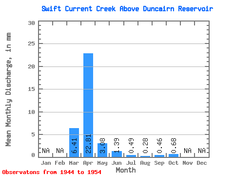
| Statistic | Jan | Feb | Mar | Apr | May | Jun | Jul | Aug | Sep | Oct | Nov | Dec | Annual |
|---|---|---|---|---|---|---|---|---|---|---|---|---|---|
| Mean | 4.94 | 17.59 | 2.37 | 1.07 | 0.38 | 0.21 | 0.35 | 0.52 | |||||
| Standard Deviation | 5.15 | 22.25 | 2.08 | 1.17 | 0.23 | 0.21 | 0.52 | 0.51 | |||||
| Min | 0.48 | 1.78 | 0.45 | 0.17 | 0.08 | 0.01 | 0.00 | 0.05 | |||||
| Max | 13.85 | 77.62 | 8.05 | 4.35 | 0.75 | 0.57 | 1.48 | 1.88 | |||||
| Coefficient of Variation | 1.04 | 1.27 | 0.88 | 1.09 | 0.60 | 0.96 | 1.48 | 0.97 |
 Return to R-Arctic Net Home Page