|
|
|||||||||||||||||
| Point ID: 5288 | Downloads | Plots | Site Data | Code: 05HD005 |
|
|
|||||||||||||||||
| Download | |
|---|---|
| Site Descriptor Information | Site Time Series Data |
| Link to all available data | |
| View: | Time Series | All |
| Units: | mm |
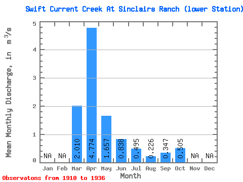
| Statistic | Jan | Feb | Mar | Apr | May | Jun | Jul | Aug | Sep | Oct | Nov | Dec | Annual |
|---|---|---|---|---|---|---|---|---|---|---|---|---|---|
| Mean | 2.01 | 4.77 | 1.66 | 0.84 | 0.49 | 0.23 | 0.35 | 0.51 | |||||
| Standard Deviation | 1.84 | 2.85 | 1.51 | 0.54 | 0.49 | 0.14 | 0.17 | 0.23 | |||||
| Min | 0.10 | 1.27 | 0.47 | 0.24 | 0.07 | 0.03 | 0.13 | 0.20 | |||||
| Max | 4.97 | 9.98 | 5.78 | 2.13 | 2.06 | 0.50 | 0.85 | 0.94 | |||||
| Coefficient of Variation | 0.92 | 0.60 | 0.91 | 0.65 | 1.00 | 0.60 | 0.50 | 0.46 |
 Return to R-Arctic Net Home Page