|
|
|||||||||||||||||
| Point ID: 5288 | Downloads | Plots | Site Data | Code: 05HD005 |
|
|
|||||||||||||||||
| Download | |
|---|---|
| Site Descriptor Information | Site Time Series Data |
| Link to all available data | |
| View: | Time Series | All |
| Units: | m3/s |
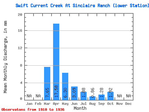
| Statistic | Jan | Feb | Mar | Apr | May | Jun | Jul | Aug | Sep | Oct | Nov | Dec | Annual |
|---|---|---|---|---|---|---|---|---|---|---|---|---|---|
| Mean | 6.61 | 15.18 | 5.45 | 2.67 | 1.63 | 0.74 | 1.10 | 1.66 | |||||
| Standard Deviation | 6.05 | 9.07 | 4.95 | 1.73 | 1.62 | 0.45 | 0.55 | 0.76 | |||||
| Min | 0.31 | 4.04 | 1.55 | 0.77 | 0.23 | 0.10 | 0.42 | 0.66 | |||||
| Max | 16.33 | 31.74 | 18.99 | 6.77 | 6.77 | 1.64 | 2.70 | 3.09 | |||||
| Coefficient of Variation | 0.92 | 0.60 | 0.91 | 0.65 | 1.00 | 0.60 | 0.50 | 0.46 |
 Return to R-Arctic Net Home Page