|
|
|||||||||||||||||
| Point ID: 5277 | Downloads | Plots | Site Data | Code: 05HA075 |
|
|
|||||||||||||||||
| Download | |
|---|---|
| Site Descriptor Information | Site Time Series Data |
| Link to all available data | |
| View: | Time Series | All |
| Units: | mm |
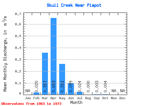
| Statistic | Jan | Feb | Mar | Apr | May | Jun | Jul | Aug | Sep | Oct | Nov | Dec | Annual |
|---|---|---|---|---|---|---|---|---|---|---|---|---|---|
| Mean | 0.02 | 0.36 | 0.65 | 0.26 | 0.10 | 0.02 | 0.00 | 0.00 | 0.00 | ||||
| Standard Deviation | 0.33 | 0.57 | 0.34 | 0.09 | 0.04 | 0.00 | 0.01 | 0.01 | |||||
| Min | 0.02 | 0.01 | 0.09 | 0.05 | 0.01 | 0.00 | 0.00 | 0.00 | 0.00 | ||||
| Max | 0.02 | 1.01 | 1.67 | 1.22 | 0.31 | 0.13 | 0.00 | 0.03 | 0.04 | ||||
| Coefficient of Variation | 0.93 | 0.88 | 1.29 | 0.89 | 1.81 | 3.16 | 3.16 |
 Return to R-Arctic Net Home Page