|
|
|||||||||||||||||
| Point ID: 5277 | Downloads | Plots | Site Data | Code: 05HA075 |
|
|
|||||||||||||||||
| Download | |
|---|---|
| Site Descriptor Information | Site Time Series Data |
| Link to all available data | |
| View: | Time Series | All |
| Units: | m3/s |
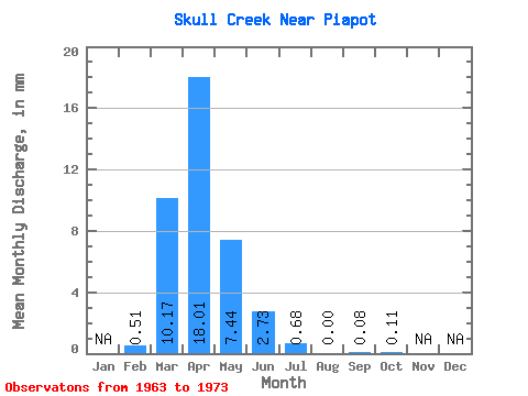
| Statistic | Jan | Feb | Mar | Apr | May | Jun | Jul | Aug | Sep | Oct | Nov | Dec | Annual |
|---|---|---|---|---|---|---|---|---|---|---|---|---|---|
| Mean | 0.38 | 7.52 | 13.34 | 5.50 | 2.02 | 0.50 | 0.00 | 0.05 | 0.07 | ||||
| Standard Deviation | 7.03 | 11.74 | 7.09 | 1.80 | 0.90 | 0.00 | 0.17 | 0.23 | |||||
| Min | 0.38 | 0.10 | 1.90 | 1.10 | 0.18 | 0.00 | 0.00 | 0.00 | 0.00 | ||||
| Max | 0.38 | 21.30 | 34.08 | 25.73 | 6.33 | 2.83 | 0.00 | 0.53 | 0.74 | ||||
| Coefficient of Variation | 0.93 | 0.88 | 1.29 | 0.89 | 1.81 | 3.16 | 3.16 |
 Return to R-Arctic Net Home Page