|
|
|||||||||||||||||
| Point ID: 525 | Downloads | Plots | Site Data | Code: 05FA001 |
|
|
|||||||||||||||||
| Download | |
|---|---|
| Site Descriptor Information | Site Time Series Data |
| Link to all available data | |
| View: | Time Series | All |
| Units: | mm |
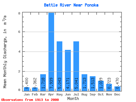
| Statistic | Jan | Feb | Mar | Apr | May | Jun | Jul | Aug | Sep | Oct | Nov | Dec | Annual |
|---|---|---|---|---|---|---|---|---|---|---|---|---|---|
| Mean | 0.40 | 0.36 | 1.72 | 7.94 | 5.04 | 4.17 | 5.04 | 1.71 | 1.51 | 1.04 | 0.72 | 0.47 | 2.83 |
| Standard Deviation | 0.42 | 0.41 | 2.45 | 7.65 | 7.29 | 5.65 | 7.50 | 2.39 | 3.71 | 1.25 | 0.69 | 0.48 | 2.12 |
| Min | 0.01 | 0.00 | 0.00 | 0.69 | 0.37 | 0.08 | 0.05 | 0.01 | 0.00 | 0.00 | 0.07 | 0.04 | 0.46 |
| Max | 1.53 | 1.86 | 14.20 | 33.00 | 41.50 | 26.70 | 36.00 | 13.60 | 23.60 | 6.94 | 3.51 | 2.08 | 8.21 |
| Coefficient of Variation | 1.04 | 1.12 | 1.43 | 0.96 | 1.45 | 1.35 | 1.49 | 1.40 | 2.45 | 1.21 | 0.95 | 1.03 | 0.75 |
 Return to R-Arctic Net Home Page