|
|
|||||||||||||||||
| Point ID: 525 | Downloads | Plots | Site Data | Code: 05FA001 |
|
|
|||||||||||||||||
| Download | |
|---|---|
| Site Descriptor Information | Site Time Series Data |
| Link to all available data | |
| View: | Time Series | All |
| Units: | m3/s |
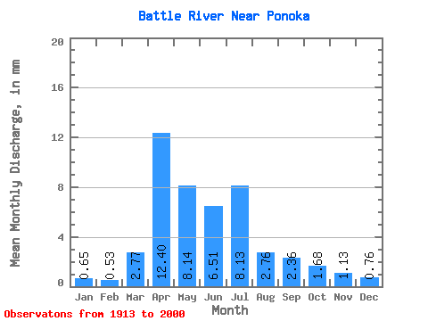
| Statistic | Jan | Feb | Mar | Apr | May | Jun | Jul | Aug | Sep | Oct | Nov | Dec | Annual |
|---|---|---|---|---|---|---|---|---|---|---|---|---|---|
| Mean | 0.58 | 0.48 | 2.51 | 11.24 | 7.38 | 5.91 | 7.38 | 2.51 | 2.14 | 1.52 | 1.02 | 0.69 | 48.76 |
| Standard Deviation | 0.61 | 0.54 | 3.58 | 10.84 | 10.67 | 8.01 | 10.98 | 3.50 | 5.25 | 1.84 | 0.97 | 0.71 | 36.56 |
| Min | 0.01 | 0.00 | 0.00 | 0.98 | 0.55 | 0.12 | 0.07 | 0.02 | 0.00 | 0.00 | 0.10 | 0.05 | 8.00 |
| Max | 2.24 | 2.48 | 20.78 | 46.74 | 60.73 | 37.82 | 52.68 | 19.90 | 33.43 | 10.16 | 4.97 | 3.04 | 141.55 |
| Coefficient of Variation | 1.04 | 1.12 | 1.43 | 0.96 | 1.45 | 1.35 | 1.49 | 1.40 | 2.45 | 1.21 | 0.95 | 1.03 | 0.75 |
 Return to R-Arctic Net Home Page