|
|
|||||||||||||||||
| Point ID: 5240 | Downloads | Plots | Site Data | Code: 05HA015 |
|
|
|||||||||||||||||
| Download | |
|---|---|
| Site Descriptor Information | Site Time Series Data |
| Link to all available data | |
| View: | Time Series | All |
| Units: | mm |
| Statistic | Jan | Feb | Mar | Apr | May | Jun | Jul | Aug | Sep | Oct | Nov | Dec | Annual |
|---|---|---|---|---|---|---|---|---|---|---|---|---|---|
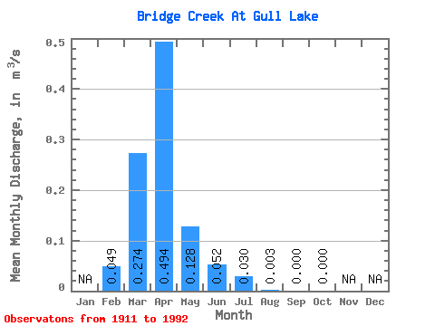
| Mean | 0.05 | 0.27 | 0.49 | 0.13 | 0.05 | 0.03 | 0.00 | 0.00 | 0.00 | ||||
| Standard Deviation | 0.05 | 0.42 | 0.76 | 0.27 | 0.15 | 0.13 | 0.01 | 0.00 | 0.00 | ||||
| Min | 0.00 | 0.00 | 0.00 | 0.00 | 0.00 | 0.00 | 0.00 | 0.00 | 0.00 | ||||
| Max | 0.13 | 1.76 | 3.54 | 1.14 | 0.79 | 0.78 | 0.08 | 0.01 | 0.01 | ||||
| Coefficient of Variation | 1.06 | 1.52 | 1.53 | 2.12 | 2.98 | 4.27 | 4.72 | 4.13 | 6.40 |
 Return to R-Arctic Net Home Page