|
|
|||||||||||||||||
| Point ID: 5240 | Downloads | Plots | Site Data | Code: 05HA015 |
|
|
|||||||||||||||||
| Download | |
|---|---|
| Site Descriptor Information | Site Time Series Data |
| Link to all available data | |
| View: | Time Series | All |
| Units: | m3/s |
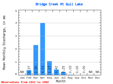
| Statistic | Jan | Feb | Mar | Apr | May | Jun | Jul | Aug | Sep | Oct | Nov | Dec | Annual |
|---|---|---|---|---|---|---|---|---|---|---|---|---|---|
| Mean | 0.32 | 1.94 | 3.38 | 0.90 | 0.36 | 0.21 | 0.02 | 0.00 | 0.00 | ||||
| Standard Deviation | 0.34 | 2.95 | 5.18 | 1.91 | 1.06 | 0.91 | 0.09 | 0.01 | 0.01 | ||||
| Min | 0.00 | 0.00 | 0.00 | 0.00 | 0.00 | 0.00 | 0.00 | 0.00 | 0.00 | ||||
| Max | 0.84 | 12.44 | 24.21 | 8.05 | 5.42 | 5.48 | 0.56 | 0.04 | 0.10 | ||||
| Coefficient of Variation | 1.06 | 1.52 | 1.53 | 2.12 | 2.98 | 4.27 | 4.72 | 4.13 | 6.40 |
 Return to R-Arctic Net Home Page