|
|
|||||||||||||||||
| Point ID: 524 | Downloads | Plots | Site Data | Code: 05EF003 |
|
|
|||||||||||||||||
| Download | |
|---|---|
| Site Descriptor Information | Site Time Series Data |
| Link to all available data | |
| View: | Time Series | All |
| Units: | mm |
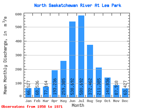
| Statistic | Jan | Feb | Mar | Apr | May | Jun | Jul | Aug | Sep | Oct | Nov | Dec | Annual |
|---|---|---|---|---|---|---|---|---|---|---|---|---|---|
| Mean | 66.53 | 68.54 | 77.16 | 193.24 | 259.38 | 538.69 | 580.69 | 372.46 | 211.38 | 140.84 | 87.92 | 63.43 | 224.95 |
| Standard Deviation | 21.17 | 23.54 | 25.97 | 105.33 | 69.87 | 193.82 | 221.21 | 85.84 | 46.44 | 52.16 | 33.22 | 22.31 | 59.61 |
| Min | 33.40 | 32.40 | 44.70 | 82.60 | 163.00 | 341.00 | 376.00 | 239.00 | 138.00 | 88.10 | 58.00 | 28.40 | 177.41 |
| Max | 99.40 | 99.80 | 135.00 | 404.00 | 365.00 | 1020.00 | 1260.00 | 514.00 | 315.00 | 262.00 | 163.00 | 97.20 | 380.95 |
| Coefficient of Variation | 0.32 | 0.34 | 0.34 | 0.55 | 0.27 | 0.36 | 0.38 | 0.23 | 0.22 | 0.37 | 0.38 | 0.35 | 0.27 |
 Return to R-Arctic Net Home Page