|
|
|||||||||||||||||
| Point ID: 524 | Downloads | Plots | Site Data | Code: 05EF003 |
|
|
|||||||||||||||||
| Download | |
|---|---|
| Site Descriptor Information | Site Time Series Data |
| Link to all available data | |
| View: | Time Series | All |
| Units: | m3/s |
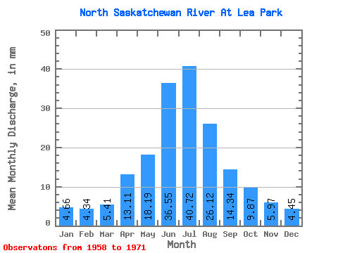
| Statistic | Jan | Feb | Mar | Apr | May | Jun | Jul | Aug | Sep | Oct | Nov | Dec | Annual |
|---|---|---|---|---|---|---|---|---|---|---|---|---|---|
| Mean | 3.73 | 3.51 | 4.33 | 10.50 | 14.56 | 29.27 | 32.60 | 20.91 | 11.49 | 7.91 | 4.78 | 3.56 | 148.84 |
| Standard Deviation | 1.19 | 1.20 | 1.46 | 5.72 | 3.92 | 10.53 | 12.42 | 4.82 | 2.52 | 2.93 | 1.81 | 1.25 | 39.44 |
| Min | 1.88 | 1.66 | 2.51 | 4.49 | 9.15 | 18.53 | 21.11 | 13.42 | 7.50 | 4.95 | 3.15 | 1.59 | 117.38 |
| Max | 5.58 | 5.11 | 7.58 | 21.95 | 20.49 | 55.43 | 70.74 | 28.86 | 17.12 | 14.71 | 8.86 | 5.46 | 252.05 |
| Coefficient of Variation | 0.32 | 0.34 | 0.34 | 0.55 | 0.27 | 0.36 | 0.38 | 0.23 | 0.22 | 0.37 | 0.38 | 0.35 | 0.27 |
 Return to R-Arctic Net Home Page