|
|
|||||||||||||||||
| Point ID: 5220 | Downloads | Plots | Site Data | Code: 05GF002 |
|
|
|||||||||||||||||
| Download | |
|---|---|
| Site Descriptor Information | Site Time Series Data |
| Link to all available data | |
| View: | Time Series | All |
| Units: | mm |
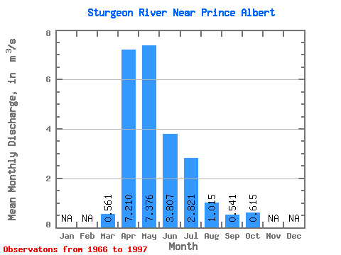
| Statistic | Jan | Feb | Mar | Apr | May | Jun | Jul | Aug | Sep | Oct | Nov | Dec | Annual |
|---|---|---|---|---|---|---|---|---|---|---|---|---|---|
| Mean | 0.56 | 7.21 | 7.38 | 3.81 | 2.82 | 1.01 | 0.54 | 0.61 | |||||
| Standard Deviation | 0.38 | 5.52 | 7.89 | 3.88 | 3.63 | 1.05 | 0.70 | 0.87 | |||||
| Min | 0.05 | 0.46 | 0.20 | 0.23 | 0.08 | 0.11 | 0.06 | 0.04 | |||||
| Max | 1.64 | 26.80 | 36.60 | 13.90 | 15.80 | 3.94 | 3.13 | 3.94 | |||||
| Coefficient of Variation | 0.68 | 0.77 | 1.07 | 1.02 | 1.29 | 1.04 | 1.29 | 1.41 |
 Return to R-Arctic Net Home Page