|
|
|||||||||||||||||
| Point ID: 5220 | Downloads | Plots | Site Data | Code: 05GF002 |
|
|
|||||||||||||||||
| Download | |
|---|---|
| Site Descriptor Information | Site Time Series Data |
| Link to all available data | |
| View: | Time Series | All |
| Units: | m3/s |
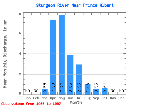
| Statistic | Jan | Feb | Mar | Apr | May | Jun | Jul | Aug | Sep | Oct | Nov | Dec | Annual |
|---|---|---|---|---|---|---|---|---|---|---|---|---|---|
| Mean | 0.29 | 3.67 | 3.87 | 1.94 | 1.48 | 0.53 | 0.28 | 0.32 | |||||
| Standard Deviation | 0.20 | 2.81 | 4.14 | 1.97 | 1.90 | 0.55 | 0.36 | 0.46 | |||||
| Min | 0.02 | 0.23 | 0.10 | 0.12 | 0.04 | 0.06 | 0.03 | 0.02 | |||||
| Max | 0.86 | 13.62 | 19.22 | 7.06 | 8.30 | 2.07 | 1.59 | 2.07 | |||||
| Coefficient of Variation | 0.68 | 0.77 | 1.07 | 1.02 | 1.29 | 1.04 | 1.29 | 1.41 |
 Return to R-Arctic Net Home Page