|
|
|||||||||||||||||
| Point ID: 520 | Downloads | Plots | Site Data | Code: 05EE007 |
|
|
|||||||||||||||||
| Download | |
|---|---|
| Site Descriptor Information | Site Time Series Data |
| Link to all available data | |
| View: | Time Series | All |
| Units: | mm |
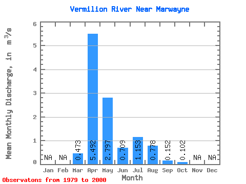
| Statistic | Jan | Feb | Mar | Apr | May | Jun | Jul | Aug | Sep | Oct | Nov | Dec | Annual |
|---|---|---|---|---|---|---|---|---|---|---|---|---|---|
| Mean | 0.47 | 5.49 | 2.80 | 0.71 | 1.15 | 0.78 | 0.15 | 0.10 | |||||
| Standard Deviation | 0.74 | 4.92 | 4.56 | 1.25 | 3.08 | 1.56 | 0.17 | 0.12 | |||||
| Min | 0.00 | 0.39 | 0.02 | 0.05 | 0.01 | 0.00 | 0.00 | 0.00 | |||||
| Max | 2.63 | 16.20 | 22.10 | 5.85 | 13.80 | 5.97 | 0.53 | 0.37 | |||||
| Coefficient of Variation | 1.57 | 0.90 | 1.63 | 1.75 | 2.67 | 2.01 | 1.16 | 1.15 |
 Return to R-Arctic Net Home Page