|
|
|||||||||||||||||
| Point ID: 520 | Downloads | Plots | Site Data | Code: 05EE007 |
|
|
|||||||||||||||||
| Download | |
|---|---|
| Site Descriptor Information | Site Time Series Data |
| Link to all available data | |
| View: | Time Series | All |
| Units: | m3/s |
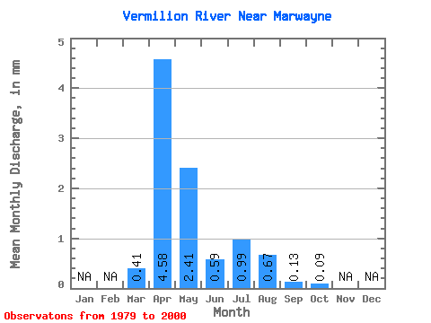
| Statistic | Jan | Feb | Mar | Apr | May | Jun | Jul | Aug | Sep | Oct | Nov | Dec | Annual |
|---|---|---|---|---|---|---|---|---|---|---|---|---|---|
| Mean | 0.17 | 1.96 | 1.03 | 0.25 | 0.42 | 0.29 | 0.05 | 0.04 | |||||
| Standard Deviation | 0.27 | 1.75 | 1.68 | 0.44 | 1.13 | 0.58 | 0.06 | 0.04 | |||||
| Min | 0.00 | 0.14 | 0.01 | 0.02 | 0.00 | 0.00 | 0.00 | 0.00 | |||||
| Max | 0.97 | 5.78 | 8.14 | 2.09 | 5.08 | 2.20 | 0.19 | 0.14 | |||||
| Coefficient of Variation | 1.57 | 0.90 | 1.63 | 1.75 | 2.67 | 2.01 | 1.16 | 1.15 |
 Return to R-Arctic Net Home Page