|
|
|||||||||||||||||
| Point ID: 5197 | Downloads | Plots | Site Data | Code: 05EG002 |
|
|
|||||||||||||||||
| Download | |
|---|---|
| Site Descriptor Information | Site Time Series Data |
| Link to all available data | |
| View: | Time Series | All |
| Units: | mm |
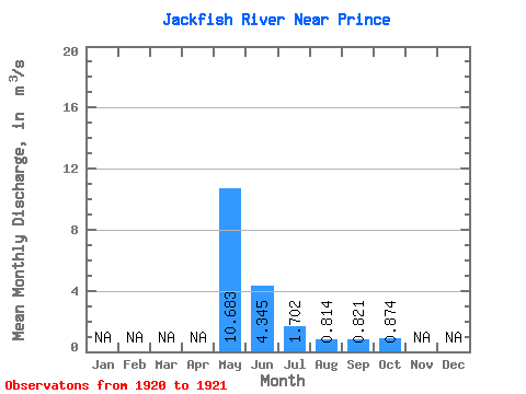
| Statistic | Jan | Feb | Mar | Apr | May | Jun | Jul | Aug | Sep | Oct | Nov | Dec | Annual |
|---|---|---|---|---|---|---|---|---|---|---|---|---|---|
| Mean | 10.68 | 4.34 | 1.70 | 0.81 | 0.82 | 0.87 | |||||||
| Standard Deviation | 13.88 | 3.61 | 1.27 | 0.76 | 0.85 | 0.89 | |||||||
| Min | 0.87 | 1.79 | 0.80 | 0.28 | 0.22 | 0.25 | |||||||
| Max | 20.50 | 6.90 | 2.60 | 1.35 | 1.42 | 1.50 | |||||||
| Coefficient of Variation | 1.30 | 0.83 | 0.75 | 0.93 | 1.03 | 1.01 |
 Return to R-Arctic Net Home Page