|
|
| Point ID: 5197 | Downloads | Plots | Site Data | Code: 05EG002 |
|
| Download | |
|---|---|
| Site Descriptor Information | Site Time Series Data |
| Link to all available data | |
|
|
|
| View: | Statistics | All |
| Units: | mm |
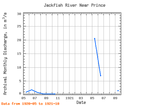
| Year | Jan | Feb | Mar | Apr | May | Jun | Jul | Aug | Sep | Oct | Nov | Dec | Annual | 1920 | 0.87 | 1.79 | 0.80 | 0.28 | 0.22 | 0.25 | 1921 | 20.50 | 6.90 | 2.60 | 1.35 | 1.42 | 1.50 |
|---|
 Return to R-Arctic Net Home Page