|
|
|||||||||||||||||
| Point ID: 5195 | Downloads | Plots | Site Data | Code: 05EF006 |
|
|
|||||||||||||||||
| Download | |
|---|---|
| Site Descriptor Information | Site Time Series Data |
| Link to all available data | |
| View: | Time Series | All |
| Units: | mm |
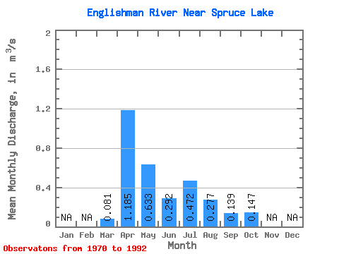
| Statistic | Jan | Feb | Mar | Apr | May | Jun | Jul | Aug | Sep | Oct | Nov | Dec | Annual |
|---|---|---|---|---|---|---|---|---|---|---|---|---|---|
| Mean | 0.08 | 1.19 | 0.63 | 0.29 | 0.47 | 0.28 | 0.14 | 0.15 | |||||
| Standard Deviation | 0.07 | 0.54 | 0.55 | 0.23 | 0.96 | 0.52 | 0.16 | 0.06 | |||||
| Min | 0.00 | 0.21 | 0.15 | 0.05 | 0.01 | 0.00 | 0.00 | 0.07 | |||||
| Max | 0.24 | 2.16 | 2.25 | 0.88 | 4.09 | 1.78 | 0.71 | 0.31 | |||||
| Coefficient of Variation | 0.91 | 0.45 | 0.86 | 0.79 | 2.02 | 1.89 | 1.16 | 0.38 |
 Return to R-Arctic Net Home Page