|
|
|||||||||||||||||
| Point ID: 5195 | Downloads | Plots | Site Data | Code: 05EF006 |
|
|
|||||||||||||||||
| Download | |
|---|---|
| Site Descriptor Information | Site Time Series Data |
| Link to all available data | |
| View: | Time Series | All |
| Units: | m3/s |
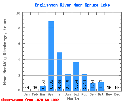
| Statistic | Jan | Feb | Mar | Apr | May | Jun | Jul | Aug | Sep | Oct | Nov | Dec | Annual |
|---|---|---|---|---|---|---|---|---|---|---|---|---|---|
| Mean | 0.55 | 7.81 | 4.31 | 1.93 | 3.22 | 1.89 | 0.92 | 1.00 | |||||
| Standard Deviation | 0.50 | 3.54 | 3.73 | 1.53 | 6.52 | 3.56 | 1.07 | 0.38 | |||||
| Min | 0.00 | 1.39 | 1.01 | 0.34 | 0.07 | 0.02 | 0.00 | 0.48 | |||||
| Max | 1.66 | 14.25 | 15.33 | 5.82 | 27.87 | 12.13 | 4.71 | 2.13 | |||||
| Coefficient of Variation | 0.91 | 0.45 | 0.86 | 0.79 | 2.02 | 1.89 | 1.16 | 0.38 |
 Return to R-Arctic Net Home Page