|
|
|||||||||||||||||
| Point ID: 5185 | Downloads | Plots | Site Data | Code: 03ME002 |
|
|
|||||||||||||||||
| Download | |
|---|---|
| Site Descriptor Information | Site Time Series Data |
| Link to all available data | |
| View: | Time Series | All |
| Units: | mm |
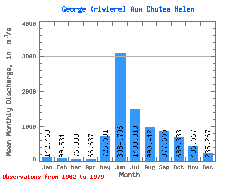
| Statistic | Jan | Feb | Mar | Apr | May | Jun | Jul | Aug | Sep | Oct | Nov | Dec | Annual |
|---|---|---|---|---|---|---|---|---|---|---|---|---|---|
| Mean | 142.46 | 99.53 | 76.39 | 66.64 | 725.08 | 3084.71 | 1499.31 | 990.41 | 877.60 | 689.33 | 436.07 | 235.27 | 739.49 |
| Standard Deviation | 34.85 | 21.01 | 16.57 | 18.35 | 924.89 | 757.53 | 450.31 | 260.16 | 258.86 | 136.16 | 141.39 | 70.39 | 85.06 |
| Min | 97.40 | 71.60 | 51.50 | 41.00 | 40.50 | 1680.00 | 888.00 | 596.00 | 573.00 | 477.00 | 278.00 | 150.00 | 628.05 |
| Max | 204.00 | 145.00 | 110.00 | 101.00 | 3560.00 | 4550.00 | 2390.00 | 1310.00 | 1560.00 | 990.00 | 678.00 | 381.00 | 871.00 |
| Coefficient of Variation | 0.24 | 0.21 | 0.22 | 0.28 | 1.28 | 0.25 | 0.30 | 0.26 | 0.29 | 0.20 | 0.32 | 0.30 | 0.12 |
 Return to R-Arctic Net Home Page