|
|
|||||||||||||||||
| Point ID: 5185 | Downloads | Plots | Site Data | Code: 03ME002 |
|
|
|||||||||||||||||
| Download | |
|---|---|
| Site Descriptor Information | Site Time Series Data |
| Link to all available data | |
| View: | Time Series | All |
| Units: | m3/s |
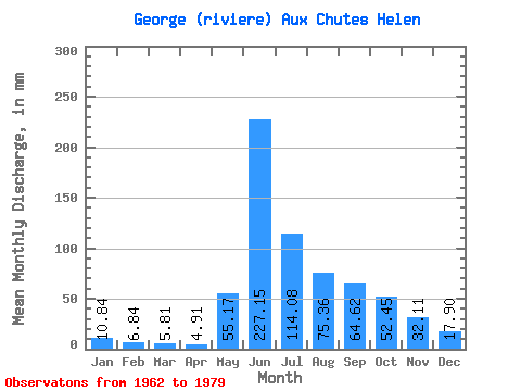
| Statistic | Jan | Feb | Mar | Apr | May | Jun | Jul | Aug | Sep | Oct | Nov | Dec | Annual |
|---|---|---|---|---|---|---|---|---|---|---|---|---|---|
| Mean | 10.84 | 6.90 | 5.81 | 4.91 | 55.16 | 227.15 | 114.07 | 75.35 | 64.62 | 52.44 | 32.11 | 17.90 | 663.02 |
| Standard Deviation | 2.65 | 1.46 | 1.26 | 1.35 | 70.36 | 55.78 | 34.26 | 19.79 | 19.06 | 10.36 | 10.41 | 5.36 | 76.26 |
| Min | 7.41 | 4.96 | 3.92 | 3.02 | 3.08 | 123.71 | 67.56 | 45.34 | 42.19 | 36.29 | 20.47 | 11.41 | 563.10 |
| Max | 15.52 | 10.05 | 8.37 | 7.44 | 270.84 | 335.05 | 181.83 | 99.66 | 114.87 | 75.32 | 49.92 | 28.99 | 780.93 |
| Coefficient of Variation | 0.24 | 0.21 | 0.22 | 0.28 | 1.28 | 0.25 | 0.30 | 0.26 | 0.29 | 0.20 | 0.32 | 0.30 | 0.12 |
 Return to R-Arctic Net Home Page