|
|
|||||||||||||||||
| Point ID: 5178 | Downloads | Plots | Site Data | Code: 03LE002 |
|
|
|||||||||||||||||
| Download | |
|---|---|
| Site Descriptor Information | Site Time Series Data |
| Link to all available data | |
| View: | Time Series | All |
| Units: | mm |
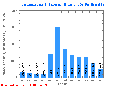
| Statistic | Jan | Feb | Mar | Apr | May | Jun | Jul | Aug | Sep | Oct | Nov | Dec | Annual |
|---|---|---|---|---|---|---|---|---|---|---|---|---|---|
| Mean | 356.06 | 273.17 | 223.56 | 206.78 | 1387.94 | 3015.56 | 1724.12 | 1359.28 | 1249.17 | 1220.28 | 886.94 | 520.44 | 1039.47 |
| Standard Deviation | 81.50 | 48.68 | 31.69 | 27.47 | 886.56 | 718.42 | 529.25 | 475.97 | 432.38 | 343.45 | 318.70 | 161.08 | 167.62 |
| Min | 245.00 | 198.00 | 171.00 | 160.00 | 220.00 | 1880.00 | 1150.00 | 689.00 | 720.00 | 590.00 | 479.00 | 323.00 | 830.83 |
| Max | 561.00 | 400.00 | 293.00 | 252.00 | 3740.00 | 4230.00 | 3070.00 | 2310.00 | 2340.00 | 1860.00 | 1430.00 | 842.00 | 1357.17 |
| Coefficient of Variation | 0.23 | 0.18 | 0.14 | 0.13 | 0.64 | 0.24 | 0.31 | 0.35 | 0.35 | 0.28 | 0.36 | 0.31 | 0.16 |
 Return to R-Arctic Net Home Page