|
|
|||||||||||||||||
| Point ID: 5178 | Downloads | Plots | Site Data | Code: 03LE002 |
|
|
|||||||||||||||||
| Download | |
|---|---|
| Site Descriptor Information | Site Time Series Data |
| Link to all available data | |
| View: | Time Series | All |
| Units: | m3/s |
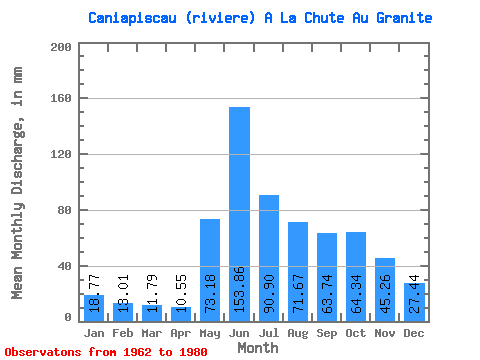
| Statistic | Jan | Feb | Mar | Apr | May | Jun | Jul | Aug | Sep | Oct | Nov | Dec | Annual |
|---|---|---|---|---|---|---|---|---|---|---|---|---|---|
| Mean | 18.77 | 13.12 | 11.79 | 10.55 | 73.17 | 153.87 | 90.89 | 71.66 | 63.74 | 64.33 | 45.26 | 27.44 | 645.78 |
| Standard Deviation | 4.30 | 2.34 | 1.67 | 1.40 | 46.74 | 36.66 | 27.90 | 25.09 | 22.06 | 18.11 | 16.26 | 8.49 | 104.14 |
| Min | 12.92 | 9.51 | 9.02 | 8.16 | 11.60 | 95.92 | 60.62 | 36.32 | 36.74 | 31.10 | 24.44 | 17.03 | 516.16 |
| Max | 29.57 | 19.21 | 15.45 | 12.86 | 197.16 | 215.83 | 161.84 | 121.78 | 119.39 | 98.05 | 72.96 | 44.39 | 843.15 |
| Coefficient of Variation | 0.23 | 0.18 | 0.14 | 0.13 | 0.64 | 0.24 | 0.31 | 0.35 | 0.35 | 0.28 | 0.36 | 0.31 | 0.16 |
 Return to R-Arctic Net Home Page