|
|
|||||||||||||||||
| Point ID: 5167 | Downloads | Plots | Site Data | Code: 03JA001 |
|
|
|||||||||||||||||
| Download | |
|---|---|
| Site Descriptor Information | Site Time Series Data |
| Link to all available data | |
| View: | Time Series | All |
| Units: | mm |
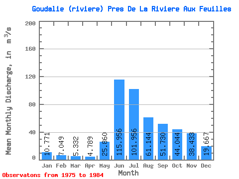
| Statistic | Jan | Feb | Mar | Apr | May | Jun | Jul | Aug | Sep | Oct | Nov | Dec | Annual |
|---|---|---|---|---|---|---|---|---|---|---|---|---|---|
| Mean | 10.77 | 7.05 | 5.33 | 4.79 | 25.86 | 115.96 | 101.96 | 61.14 | 51.73 | 44.04 | 38.43 | 19.67 | 41.53 |
| Standard Deviation | 3.51 | 2.27 | 1.70 | 1.56 | 14.90 | 52.96 | 32.80 | 18.08 | 16.51 | 10.09 | 18.71 | 6.96 | 9.16 |
| Min | 4.30 | 2.19 | 1.44 | 1.14 | 5.94 | 32.60 | 58.10 | 39.20 | 26.60 | 25.40 | 17.70 | 10.90 | 32.19 |
| Max | 16.20 | 10.10 | 7.28 | 6.58 | 58.90 | 214.00 | 156.00 | 90.60 | 74.90 | 59.50 | 84.40 | 32.10 | 56.09 |
| Coefficient of Variation | 0.33 | 0.32 | 0.32 | 0.33 | 0.58 | 0.46 | 0.32 | 0.30 | 0.32 | 0.23 | 0.49 | 0.35 | 0.22 |
 Return to R-Arctic Net Home Page