|
|
|||||||||||||||||
| Point ID: 5167 | Downloads | Plots | Site Data | Code: 03JA001 |
|
|
|||||||||||||||||
| Download | |
|---|---|
| Site Descriptor Information | Site Time Series Data |
| Link to all available data | |
| View: | Time Series | All |
| Units: | m3/s |
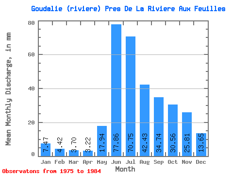
| Statistic | Jan | Feb | Mar | Apr | May | Jun | Jul | Aug | Sep | Oct | Nov | Dec | Annual |
|---|---|---|---|---|---|---|---|---|---|---|---|---|---|
| Mean | 7.47 | 4.46 | 3.70 | 3.22 | 17.94 | 77.86 | 70.73 | 42.42 | 34.74 | 30.56 | 25.81 | 13.64 | 339.59 |
| Standard Deviation | 2.43 | 1.43 | 1.18 | 1.05 | 10.34 | 35.56 | 22.76 | 12.54 | 11.08 | 7.00 | 12.56 | 4.83 | 74.88 |
| Min | 2.98 | 1.38 | 1.00 | 0.77 | 4.12 | 21.89 | 40.31 | 27.20 | 17.86 | 17.62 | 11.89 | 7.56 | 263.16 |
| Max | 11.24 | 6.38 | 5.05 | 4.42 | 40.86 | 143.70 | 108.23 | 62.86 | 50.30 | 41.28 | 56.67 | 22.27 | 458.56 |
| Coefficient of Variation | 0.33 | 0.32 | 0.32 | 0.33 | 0.58 | 0.46 | 0.32 | 0.30 | 0.32 | 0.23 | 0.49 | 0.35 | 0.22 |
 Return to R-Arctic Net Home Page