|
|
|||||||||||||||||
| Point ID: 5162 | Downloads | Plots | Site Data | Code: 03HA012 |
|
|
|||||||||||||||||
| Download | |
|---|---|
| Site Descriptor Information | Site Time Series Data |
| Link to all available data | |
| View: | Time Series | All |
| Units: | mm |
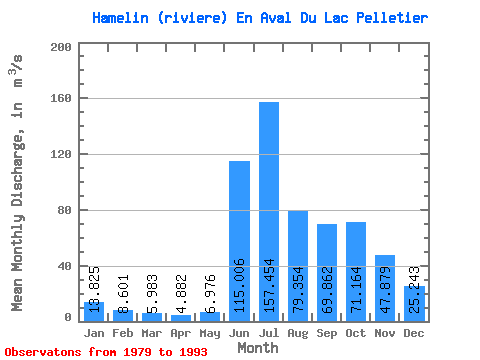
| Statistic | Jan | Feb | Mar | Apr | May | Jun | Jul | Aug | Sep | Oct | Nov | Dec | Annual |
|---|---|---|---|---|---|---|---|---|---|---|---|---|---|
| Mean | 13.82 | 8.60 | 5.98 | 4.88 | 6.98 | 115.01 | 157.45 | 79.35 | 69.86 | 71.16 | 47.88 | 25.24 | 50.14 |
| Standard Deviation | 4.07 | 2.94 | 2.12 | 1.48 | 6.27 | 38.79 | 34.62 | 21.91 | 20.89 | 18.29 | 12.70 | 6.29 | 5.99 |
| Min | 9.50 | 5.38 | 3.41 | 3.07 | 3.08 | 4.98 | 75.90 | 51.90 | 37.00 | 45.40 | 33.70 | 18.60 | 37.62 |
| Max | 23.90 | 15.80 | 10.90 | 7.99 | 27.60 | 153.00 | 211.00 | 118.00 | 119.00 | 104.00 | 79.30 | 40.40 | 59.85 |
| Coefficient of Variation | 0.29 | 0.34 | 0.35 | 0.30 | 0.90 | 0.34 | 0.22 | 0.28 | 0.30 | 0.26 | 0.27 | 0.25 | 0.12 |
 Return to R-Arctic Net Home Page