|
|
|||||||||||||||||
| Point ID: 5162 | Downloads | Plots | Site Data | Code: 03HA012 |
|
|
|||||||||||||||||
| Download | |
|---|---|
| Site Descriptor Information | Site Time Series Data |
| Link to all available data | |
| View: | Time Series | All |
| Units: | m3/s |
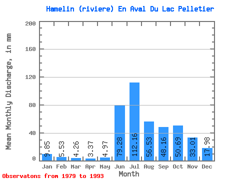
| Statistic | Jan | Feb | Mar | Apr | May | Jun | Jul | Aug | Sep | Oct | Nov | Dec | Annual |
|---|---|---|---|---|---|---|---|---|---|---|---|---|---|
| Mean | 9.85 | 5.58 | 4.26 | 3.37 | 4.97 | 79.28 | 112.14 | 56.52 | 48.16 | 50.69 | 33.01 | 17.98 | 420.88 |
| Standard Deviation | 2.90 | 1.91 | 1.51 | 1.02 | 4.47 | 26.74 | 24.66 | 15.61 | 14.40 | 13.03 | 8.75 | 4.48 | 50.26 |
| Min | 6.77 | 3.49 | 2.43 | 2.12 | 2.19 | 3.43 | 54.06 | 36.97 | 25.51 | 32.34 | 23.23 | 13.25 | 315.73 |
| Max | 17.02 | 10.25 | 7.76 | 5.51 | 19.66 | 105.47 | 150.28 | 84.04 | 82.03 | 74.07 | 54.67 | 28.77 | 502.34 |
| Coefficient of Variation | 0.29 | 0.34 | 0.35 | 0.30 | 0.90 | 0.34 | 0.22 | 0.28 | 0.30 | 0.26 | 0.27 | 0.25 | 0.12 |
 Return to R-Arctic Net Home Page