|
|
|||||||||||||||||
| Point ID: 5159 | Downloads | Plots | Site Data | Code: 03HA001 |
|
|
|||||||||||||||||
| Download | |
|---|---|
| Site Descriptor Information | Site Time Series Data |
| Link to all available data | |
| View: | Time Series | All |
| Units: | mm |
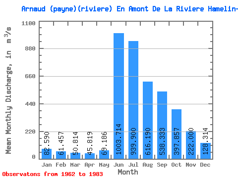
| Statistic | Jan | Feb | Mar | Apr | May | Jun | Jul | Aug | Sep | Oct | Nov | Dec | Annual |
|---|---|---|---|---|---|---|---|---|---|---|---|---|---|
| Mean | 82.59 | 61.46 | 50.81 | 45.82 | 69.19 | 1003.71 | 939.90 | 616.19 | 538.33 | 397.86 | 222.00 | 128.31 | 345.12 |
| Standard Deviation | 21.34 | 13.40 | 9.42 | 7.05 | 43.38 | 339.12 | 237.95 | 151.24 | 144.32 | 104.30 | 49.52 | 38.45 | 61.84 |
| Min | 52.00 | 46.10 | 38.70 | 33.70 | 33.40 | 366.00 | 567.00 | 405.00 | 341.00 | 246.00 | 134.00 | 72.40 | 208.16 |
| Max | 134.00 | 101.00 | 77.00 | 59.20 | 241.00 | 1630.00 | 1440.00 | 1060.00 | 873.00 | 607.00 | 306.00 | 243.00 | 513.77 |
| Coefficient of Variation | 0.26 | 0.22 | 0.18 | 0.15 | 0.63 | 0.34 | 0.25 | 0.24 | 0.27 | 0.26 | 0.22 | 0.30 | 0.18 |
 Return to R-Arctic Net Home Page