|
|
|||||||||||||||||
| Point ID: 5159 | Downloads | Plots | Site Data | Code: 03HA001 |
|
|
|||||||||||||||||
| Download | |
|---|---|
| Site Descriptor Information | Site Time Series Data |
| Link to all available data | |
| View: | Time Series | All |
| Units: | m3/s |
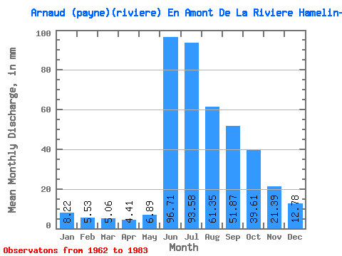
| Statistic | Jan | Feb | Mar | Apr | May | Jun | Jul | Aug | Sep | Oct | Nov | Dec | Annual |
|---|---|---|---|---|---|---|---|---|---|---|---|---|---|
| Mean | 8.22 | 5.58 | 5.06 | 4.42 | 6.89 | 96.72 | 93.57 | 61.34 | 51.87 | 39.61 | 21.39 | 12.77 | 404.91 |
| Standard Deviation | 2.12 | 1.22 | 0.94 | 0.68 | 4.32 | 32.68 | 23.69 | 15.06 | 13.91 | 10.38 | 4.77 | 3.83 | 72.56 |
| Min | 5.18 | 4.18 | 3.85 | 3.25 | 3.33 | 35.27 | 56.45 | 40.32 | 32.86 | 24.49 | 12.91 | 7.21 | 244.22 |
| Max | 13.34 | 9.16 | 7.67 | 5.70 | 23.99 | 157.06 | 143.36 | 105.53 | 84.12 | 60.43 | 29.48 | 24.19 | 602.77 |
| Coefficient of Variation | 0.26 | 0.22 | 0.18 | 0.15 | 0.63 | 0.34 | 0.25 | 0.24 | 0.27 | 0.26 | 0.22 | 0.30 | 0.18 |
 Return to R-Arctic Net Home Page