|
|
|||||||||||||||||
| Point ID: 5142 | Downloads | Plots | Site Data | Code: 03EE003 |
|
|
|||||||||||||||||
| Download | |
|---|---|
| Site Descriptor Information | Site Time Series Data |
| Link to all available data | |
| View: | Time Series | All |
| Units: | mm |
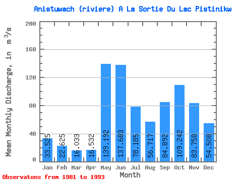
| Statistic | Jan | Feb | Mar | Apr | May | Jun | Jul | Aug | Sep | Oct | Nov | Dec | Annual |
|---|---|---|---|---|---|---|---|---|---|---|---|---|---|
| Mean | 33.52 | 22.62 | 16.03 | 16.53 | 139.19 | 137.68 | 78.19 | 56.72 | 84.89 | 109.24 | 83.76 | 54.51 | 69.53 |
| Standard Deviation | 8.48 | 5.84 | 2.01 | 6.13 | 33.78 | 36.47 | 26.22 | 19.68 | 39.67 | 37.06 | 15.67 | 12.33 | 7.96 |
| Min | 23.80 | 17.00 | 12.90 | 9.69 | 71.30 | 89.70 | 36.20 | 20.00 | 17.90 | 59.20 | 64.70 | 40.20 | 50.99 |
| Max | 52.60 | 38.20 | 19.20 | 28.50 | 194.00 | 212.00 | 127.00 | 80.80 | 156.00 | 182.00 | 116.00 | 79.80 | 80.74 |
| Coefficient of Variation | 0.25 | 0.26 | 0.13 | 0.37 | 0.24 | 0.27 | 0.34 | 0.35 | 0.47 | 0.34 | 0.19 | 0.23 | 0.11 |
 Return to R-Arctic Net Home Page