|
|
|||||||||||||||||
| Point ID: 5142 | Downloads | Plots | Site Data | Code: 03EE003 |
|
|
|||||||||||||||||
| Download | |
|---|---|
| Site Descriptor Information | Site Time Series Data |
| Link to all available data | |
| View: | Time Series | All |
| Units: | m3/s |
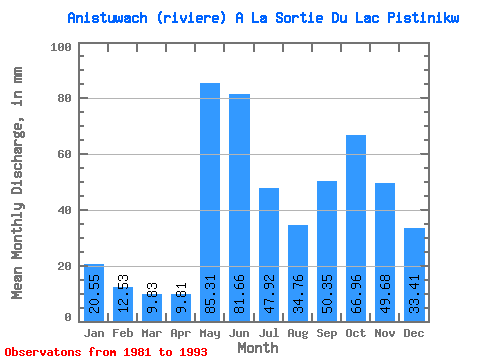
| Statistic | Jan | Feb | Mar | Apr | May | Jun | Jul | Aug | Sep | Oct | Nov | Dec | Annual |
|---|---|---|---|---|---|---|---|---|---|---|---|---|---|
| Mean | 20.55 | 12.63 | 9.82 | 9.81 | 85.30 | 81.67 | 47.91 | 34.76 | 50.35 | 66.94 | 49.68 | 33.40 | 502.17 |
| Standard Deviation | 5.20 | 3.26 | 1.23 | 3.64 | 20.70 | 21.63 | 16.07 | 12.06 | 23.53 | 22.71 | 9.30 | 7.56 | 57.46 |
| Min | 14.59 | 9.49 | 7.91 | 5.75 | 43.69 | 53.20 | 22.18 | 12.26 | 10.62 | 36.28 | 38.38 | 24.64 | 368.26 |
| Max | 32.23 | 21.33 | 11.77 | 16.90 | 118.89 | 125.75 | 77.83 | 49.52 | 92.53 | 111.53 | 68.80 | 48.90 | 583.11 |
| Coefficient of Variation | 0.25 | 0.26 | 0.13 | 0.37 | 0.24 | 0.27 | 0.34 | 0.35 | 0.47 | 0.34 | 0.19 | 0.23 | 0.11 |
 Return to R-Arctic Net Home Page