|
|
|||||||||||||||||
| Point ID: 5138 | Downloads | Plots | Site Data | Code: 03ED002 |
|
|
|||||||||||||||||
| Download | |
|---|---|
| Site Descriptor Information | Site Time Series Data |
| Link to all available data | |
| View: | Time Series | All |
| Units: | mm |
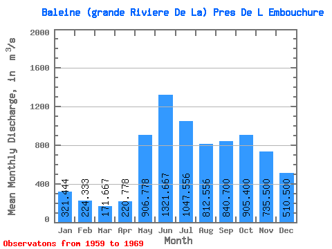
| Statistic | Jan | Feb | Mar | Apr | May | Jun | Jul | Aug | Sep | Oct | Nov | Dec | Annual |
|---|---|---|---|---|---|---|---|---|---|---|---|---|---|
| Mean | 321.44 | 224.33 | 171.67 | 220.78 | 906.78 | 1321.67 | 1047.56 | 812.56 | 840.70 | 905.40 | 735.50 | 510.50 | 663.87 |
| Standard Deviation | 37.59 | 31.86 | 20.69 | 128.66 | 273.80 | 338.67 | 331.78 | 290.35 | 260.52 | 220.12 | 123.09 | 43.95 | 100.29 |
| Min | 278.00 | 182.00 | 145.00 | 133.00 | 379.00 | 840.00 | 744.00 | 461.00 | 451.00 | 608.00 | 589.00 | 436.00 | 510.42 |
| Max | 383.00 | 273.00 | 212.00 | 517.00 | 1260.00 | 1850.00 | 1860.00 | 1210.00 | 1380.00 | 1170.00 | 891.00 | 578.00 | 828.33 |
| Coefficient of Variation | 0.12 | 0.14 | 0.12 | 0.58 | 0.30 | 0.26 | 0.32 | 0.36 | 0.31 | 0.24 | 0.17 | 0.09 | 0.15 |
 Return to R-Arctic Net Home Page